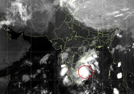
Cyclone Murasu Strengthens as Andhra Coast Faces Powerful Winds and Heavy Rain

Cyclone Murasu has intensified into a severe cyclonic storm over the west-central and adjoining southwest Bay of Bengal, with the India Meteorological Department (IMD) forecasting that it will cross the south Andhra Pradesh coast between midnight on November 2 and the early hours of November 3.
The storm is expected to bring sustained winds of 100–110 kilometres per hour, with gusts reaching 120 kmph, posing a serious weather threat to coastal areas. The projected landfall zone lies between Nellore and Narsapur, close to Ongole, according to the IMD’s coastal weather bulletin.
Cyclone Moves Towards the Andhra Pradesh Coast
In its bulletin issued early on November 2, the IMD reported that Murasu had been moving northwestwards after travelling at around 20 kmph over the preceding six hours. At 2:30 am IST, the storm’s centre was located near latitude 13.6°N and longitude 82.5°E.
At that point, it was approximately 260 kilometres east-northeast of Chennai, 290 kilometres east-southeast of Nellore and 330 kilometres southeast of Ongole.
The system is forecast to continue towards the Andhra Pradesh coastline. Its precise landfall location and local effects may change as it approaches land, making updated weather bulletins important for residents and local authorities.
Winds Could Reach 120 kmph
Murasu is expected to maintain severe cyclonic storm intensity when it crosses the coast. Winds of 100–110 kmph, accompanied by stronger gusts, could damage vulnerable structures, break tree branches, disrupt electricity supplies and make road travel hazardous.
Coastal communities may also experience difficult conditions because of rough seas and strong winds. Fishing and other maritime activities can become dangerous as weather conditions deteriorate.
Residents should not assume that conditions will remain safe simply because the cyclone’s centre is offshore. Strong winds and heavy rain can affect areas beyond the immediate landfall point.
Heavy Rain and Coastal Flooding Risks
The IMD has forecast widespread rain or thundershowers along the north and south Andhra Pradesh coasts. Visibility may fall during intense rainfall, while sea conditions could deteriorate from moderate or rough to very rough during thunderstorms.
The department’s coastal bulletin also warns that a storm surge of approximately 1.0–1.5 metres above the astronomical tide could inundate low-lying parts of south coastal Andhra Pradesh around landfall. The bulletin identifies the Bapatla area and parts of Krishna and Prakasam districts as locations where the peak surge could be significant.
Storm surge occurs when strong winds and low atmospheric pressure push seawater towards the coast. When it coincides with high tide, water can move into low-lying coastal settlements and other vulnerable areas. The actual extent of flooding will depend on local geography, tides and the storm’s track and intensity.
What Residents Should Do
People living in coastal and low-lying areas should closely follow official instructions issued by the IMD, state disaster-management authorities and district administrations. Anyone advised to evacuate should move to the designated safe location without delay.
Residents can reduce risks by securing loose outdoor objects, staying away from damaged power lines, keeping mobile phones charged and preparing essential medicines, drinking water, identification documents and emergency supplies.
People should avoid beaches, sea-facing areas, flooded roads and unnecessary travel during severe weather. Fishermen and operators of small boats should follow official restrictions and port advisories rather than attempting to work in rough seas.
Households should also plan how to contact family members if electricity or mobile services are disrupted. Older people, children, persons with disabilities and those requiring regular medication may need additional assistance during an evacuation.
Why the Next Few Hours Matter
The final approach to the coastline is a critical period because the storm’s movement, wind strength and rainfall pattern can affect the level of danger in individual districts. Forecasts provide an expected track, but they cannot guarantee the exact point where the cyclone will cross land or the precise severity of local impacts.
For Andhra Pradesh, the principal concerns are damaging winds, heavy rainfall, possible flooding in low-lying coastal areas and disruptions to transport and essential services. Timely warnings and compliance with local safety instructions can help reduce the risk to life.
The public should therefore rely on the latest official updates rather than unverified social-media messages. Forecasts and warnings may be revised as new observations become available.