India Strengthens Its Navigation Ambitions as ISRO Successfully Deploys NVS-03 Satellite

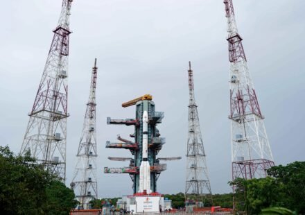
India has achieved another milestone in its space programme after the Indian Space Research Organisation (ISRO) successfully placed the NVS-03 navigation satellite into its intended orbit using the GSLV-F18 rocket. The mission marks an important step in strengthening India's independent satellite navigation capabilities and supporting the continuity of navigation services through its indigenous NavIC system.
The launch took place on October 30, 2026, from the Second Launch Pad at the Satish Dhawan Space Centre in Sriharikota, Andhra Pradesh. According to ISRO, GSLV-F18 successfully delivered NVS-03 into a Geosynchronous Transfer Orbit, completing the mission's primary launch objective. The flight was the 20th mission of India's Geosynchronous Satellite Launch Vehicle programme.
Why the NVS-03 Mission Matters
NVS-03 is the third satellite in India's second-generation NVS navigation satellite series. These satellites are designed to maintain and improve the availability of services provided by the Indian Regional Navigation Satellite System, commonly known as NavIC.
Satellite navigation has become essential to modern life. It helps determine locations, calculate routes and provide precise timing information to compatible systems. These capabilities support applications ranging from road navigation and transport operations to maritime activities, emergency response and infrastructure management.
For India, maintaining a dependable domestic navigation system is also a strategic priority. A stronger indigenous capability gives the country greater control over an important technology used across civilian and specialised applications.
The successful deployment of NVS-03 is a significant step, although the satellite must complete its subsequent deployment and commissioning activities before its operational contribution can be fully assessed.
Indigenous Atomic Clock Adds to the Satellite's Technology
One of the notable features of NVS-03 is its inclusion of an indigenous atomic clock alongside procured atomic clocks. Accurate timekeeping is fundamental to satellite navigation because receivers use signals from multiple satellites to calculate their position.
Even small timing errors can affect positioning calculations. Improving the reliability of onboard timing technology is therefore important for the performance of a navigation satellite.
ISRO has also incorporated the L1 navigation signal into NVS-03, in addition to the L5 and S signals used by the system. The additional signal is intended to support a wider range of compatible receivers and navigation applications.
The practical benefits will depend on the satellite's commissioning, the performance of the wider NavIC constellation and the compatibility of receivers used by individuals, businesses and public agencies.
What Is NavIC?
NavIC, or Navigation with Indian Constellation, is India's regional satellite navigation system. It was developed to provide positioning, navigation and timing services over the Indian mainland and a region extending approximately 1,500 kilometres beyond India's geopolitical boundary.
The system is designed to serve users in sectors such as transport, maritime navigation, disaster management and location-based services. It can also support specialised applications that require dependable positioning and timing information.
NavIC is not simply an alternative name for GPS. GPS is operated by the United States, while NavIC is India's own navigation system. Other global and regional systems include Europe's Galileo, Russia's GLONASS and China's BeiDou.
Having a domestic system gives India another source of navigation capability. However, the availability of NavIC services on a particular smartphone, vehicle or other device depends on whether its receiver supports the relevant signals and frequencies.
Potential Benefits for Transport and Public Services
A stronger NavIC constellation could help improve the continuity of navigation services for compatible users. Road transport operators may benefit from location and timing information, while maritime users can use satellite navigation to support route planning and vessel tracking.
Accurate positioning and timing can also be useful in surveying, infrastructure projects, logistics and certain emergency-response operations. Public authorities may use navigation data to support fleet management and other location-dependent services.
These benefits should not be interpreted as an immediate improvement for every smartphone user. The effect of NVS-03 will depend on how it performs after commissioning, the overall health of the satellite constellation and the capabilities of devices receiving its signals.
The mission is therefore best understood as an investment in the infrastructure that supports navigation, rather than a promise that all users will experience an instant change.
Why Launch Vehicle Reliability Remains Important
The GSLV-F18 mission also highlights the role of India's launch vehicle programme in deploying strategic space infrastructure. Navigation satellites require accurate placement into their intended transfer orbits before they can proceed through the steps needed to reach their operational positions.
Successful launch and deployment are important stages, but they do not mark the end of the process. Satellite health checks, orbital manoeuvres and commissioning activities help establish whether a spacecraft is ready to provide its intended services.
As India continues to expand its navigation capabilities, the performance of both its satellites and launch vehicles will remain important to the reliability of the overall system.
The Next Step for India's Navigation Network
NVS-03's successful deployment strengthens the foundation for India's next-generation navigation programme. Further satellites in the series are expected to contribute to the longer-term effort to improve service continuity and strengthen the constellation.
The outcome will depend on the operational performance of each spacecraft and the coordinated functioning of the wider system. Continued investment in satellite technology, atomic clocks, signal capability and receiver compatibility will also influence how widely NavIC can be used.
The bottom line: ISRO's successful GSLV-F18 mission has moved NVS-03 into its intended transfer orbit, marking an important milestone for India's domestic navigation infrastructure. The satellite's new signal capability and onboard timing technology could support future improvements, while its actual contribution will become clearer after commissioning and integration into the NavIC system.